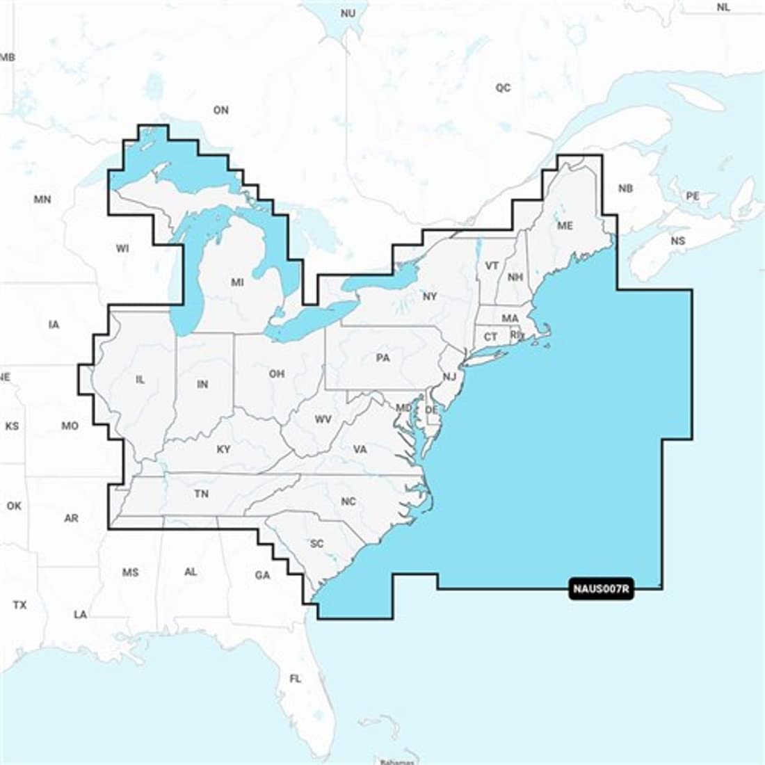
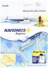
Navionics U.S East Regions(NAUS007R)- Marine and Lake Charts with Preloaded Micro SD Format(010-C1370-30)
Navionics U.S East Regions(NAUS007R)- Marine and Lake Charts with Preloade...
Navionics U.S East Regions(NAUS007R)- Marine and Lake Charts with Preloaded Micro SD Format(010-C1370-30)
Navionics U.S East Regions(NAUS007R)- Marine and Lake Charts with Preloade...
Integrated Garmin and Navionics content provides exceptional coverage, clarity, and detail in a familiar look and feel | Easy access to dail...

Post Your Offer
Post your offer and receive alerts based on your preferences.
Anything Boating
Tennessee https://anythingboating.com/navionics-naus...
Visit Website
IPC-Store
https://www.amazon.com/gp/product/b09x5ty8...
Visit Website
Citimarine Store
Florida https://citimarinestore.com/en/electronic-...
Visit Website
Newegg.com - IPC Store
https://www.newegg.com/p/2wp-001r-00012?it...
Visit Website
PHD Tackle
https://phdtackle.com/product/navionics-pl...
Visit Website
Walleye Tackle Store
Ohio https://www.walleyetacklestore.com/navioni...
Visit Website
Gps4us
California https://www.gps4us.com/navionics-plus-naus...
Visit Website
Anchor Express
Massachusetts https://www.anchorexpress.com/navionics-na...
Visit Website
Hodges Marine
Florida https://www.hodgesmarine.com/nav010-c1370-...
Visit Website
Wholesaler Elite
https://www.wholesalerelite.com/products/n...
Visit Website
Neptunian Marine
https://neptunianmarine.com/products/navio...
Visit Website
Beach Audio
California https://www.beachaudio.com/navionics-010-c...
Visit Website
Global Fishing Gear
https://globalfishinggear.us/products/navi...
Visit Website
BoatsnMotors
Massachusetts https://boatsnmotors.com/products/navionic...
Visit Website
OpenFisherman.com
Florida https://openfisherman.com/products/navioni...
Visit Website
Fast Boat Parts
Florida https://www.fastboatparts.com/shop/navioni...
Visit Website
Carrick Marine
Florida https://carrickmarine.com/products/navioni...
Visit Website
The Outdoor Warehouse
California https://www.theoutdoorwarehouse.com/produc...
Visit Website
The Boat Parts Warehouse
https://theboatpartswarehouse.com/products...
Visit Website
D&B Marine Supplies
Florida https://dbmarinesupplies.com/products/navi...
Visit Website
Autoplicity.com
Illinois https://autoplicity.com/15486451-navionics...
Visit Website
Guabi Distribution
https://guabidistribution.com/products/nav...
Visit Website
The GPS Store
North Carolina https://www.thegpsstore.com/gps-maps-softw...
Visit Website
Life Raft Professionals
Florida https://www.liferaftprofessionals.com/prod...
Visit Website
Bridgeview Harbour Marina
New York https://www.bridgeviewharbour.com/products...
Visit Website
Defender Marine
https://defender.com/en_us/navionics-elect...
Visit Website
Overtons.com
North Carolina https://www.overtons.com/navionics-naus007...
Visit Website
Camping World
Colorado https://www.campingworld.com/navionics-nau...
Visit Website
Scheels
Minnesota https://www.scheels.com/p/82124599169/?utm...
Visit Website
West Marine
California https://www.westmarine.com/on/demandware.s...
Visit Website
yak-works.com
North Carolina https://yak-works.com/products/navionics-s...
Visit Website
Russell Marine Products
Kansas https://www.russellmarineproducts.com/navi...
Visit Website
SurvivalAtSea.com
Maine https://www.survivalatsea.com/product/navi...
Visit Website
Tackle Warehouse
California https://www.tacklewarehouse.com/navionics_...
Visit Website
FishUSA
Pennsylvania https://www.fishusa.com/garmin-navionics/?...
Visit Website
Cabela's
Nebraska https://www.cabelas.com/shop/en/navionics-...
Visit Website
Bass Pro Shops
Missouri https://www.basspro.com/shop/en/navionics-...
Visit Website
Garmin Worldwide
https://www.garmin.com/en-us/p/843219/pn/0...
Visit Website
Garmin - United States
Florida https://www.garmin.com/en-us/p/843219/pn/0...
Visit Website
You may also like
Integrated Garmin and Navionics content provides exceptional coverage, clarity, and detail in a familiar look and feel | Easy access to daily chart updates is available via the Navionics Chart Installer software or wirelessly via the Plotter Sync feature with the Navionics Boating app (The Plotter Sync feature requires the use of the Navionics Boating app on your compatible smart device with an active subscription of the same area.) | Navionics advanced dock-to dock route guidance technology uses your boat settings, along with chart data and frequently traveled routes, to calculate a suggested path to follow (Route guidance is for planning purposes only and does not replace safe navigation operations.) | For improved fishing and navigation, SonarChart HD bathymetry maps display up to 1 (0.5 meter) contours, providing a more detailed depiction of bottom structure | SonarChart Live mapping feature allows boaters to create new personal 1 HD bathymetry maps that display in real time on the screens of their compatible plotters while navigating
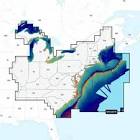
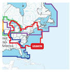
Navionics U.S East Regions(NAUS007R)- Marine and Lake Charts with Preloaded Micro SD Format(010-C1370-30)Detailed coverage of the lakes, rivers, and coasts of Connecticut, Delaware, Illinois, Indiana, Kentucky, Maine, Maryland, Massachusetts, Michigan, New Hampshire, New Jersey, New York, North Carolina, Ohio, Pennsylvania, Rhode Island, South Carolina, Tennessee, Vermont, Virginia, and West Virginia.Get the world’s No. 1 choice in marine mapping — with the best, most up-to-date Navionics+ cartography on your compatible chartplotter. For offshore or inland waters, this all-in-one solution offers detail-rich integrated mapping of coastal waters, lakes, rivers, and more. Get SonarChart 1’ (0.5 meters) HD bathymetry maps, advanced features such as dock-to-dock route guidance technology (depending on chartplotter model), live mapping, and Plotter Sync to provide wireless access to daily updates. The Navionics Chart Installer software also ensures the freshest chart data every time out. Navionics route guidance solutions give you a suggested dock-to-dock path to follow through channels, inlets, marina entrances, and...
Regional Links
You may also like
We use cookies to enhance your browsing experience, By clicking "I Understand", you consent to our use of cookies.