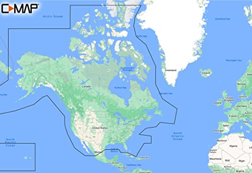
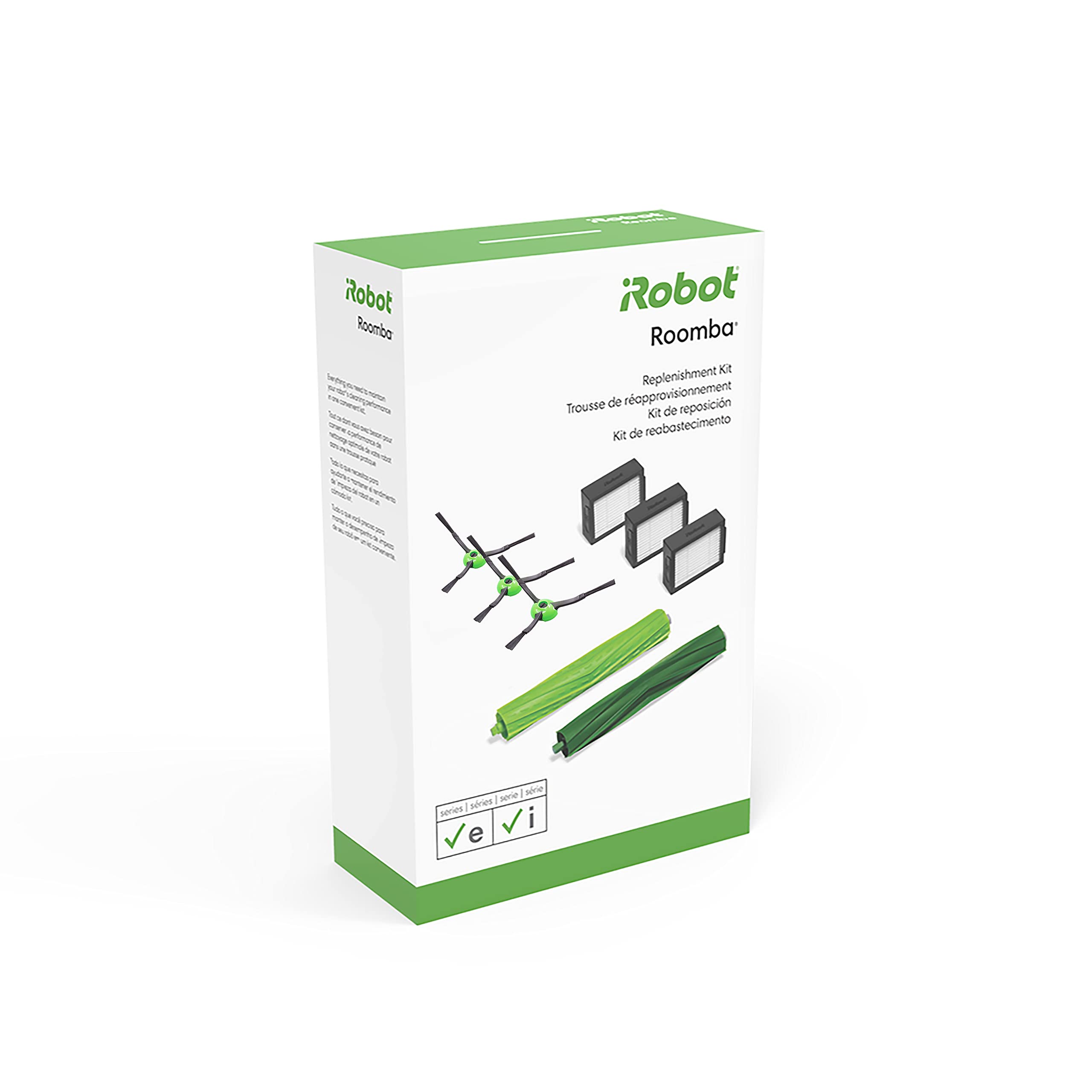
ULTRA-WIDE COVERAGE: Our largest geographical coverage, without compromising on chart quality | HIGH-RES BATHY: Helps you identify shallow areas, drop-offs, ledges, holes or humps. Now includes compiled and quality-controlled Genesis detail as part of singular HRB layer | FULL FEATURED VECTOR CHARTS: Making navigation easy by giving you accurate, up-to-date vector chart detail derive from official Hydrographic Office...
close terms and conditions
Terms and Conditions ("Terms")
Please read these Terms and Conditions ("Terms", "Terms and Conditions") carefully before using the www.theinternetmarketplace.com website (the "Service", "Website") operated by The Internet Marketplace ("us", "we", or "our").
Access to and use of this Website and the products and services available through this Website (collectively, the "Services") are subject to the following terms, conditions and notices (the "Terms of Service"). By using the Services, you are agreeing to all of the Terms of Service, as may be updated by us from time to time. You should check this page regularly to take notice of any changes we may have made to the Terms of Service.
If you continue to browse and use this website, you are agreeing to comply with and be bound by the following terms and conditions of use, which together with our privacy policy govern our relationship with you in relation to this website.
By accessing or using the Service you agree to be bound by these Terms. If you disagree with any part of the terms then you may not access the Service.
Access to this Website is permitted on a temporary basis, and we reserve the right to withdraw or amend the Services without notice. We will not be liable if for any reason this Website is unavailable at any time or for any period. From time to time, we may restrict access to some parts or all of this Website. We may restrict access to to specific ip addresses or users or geo locations or by any criteria at our discretion. We may disable your user ID and password in our sole discretion without notice or explanation.
This Website contains links to other websites (the "Linked Sites"), which are not operated by us. These links are provided for your convenience to provide further information. They do not signify that we endorse the website(s). We have no responsibility for the content of the linked website(s). We have no control over the Linked Sites and accept no responsibility for them or for any loss or damage that may arise from your use of them. Your use of the Linked Sites will be subject to the terms of use and service contained within each such site.
Our privacy policy, which sets out how we will use your information, can be
found at
https://www.theinternetmarketplace.com/privacy_policy. By using this
Website, you consent to the processing described therein and warrant that all
data provided by you is accurate.
You must not misuse this Website. You will not: commit or encourage a criminal
offense; transmit or distribute a virus, trojan, worm, logic bomb or any other
material which is malicious, technologically harmful, in breach of confidence or
in any way offensive or obscene; hack into any aspect of the Service; corrupt
data; cause annoyance to other users; infringe upon the rights of any other
person's proprietary rights; send any unsolicited advertising or promotional
material, commonly referred to as "spam"; or attempt to affect the performance
or functionality of any computer facilities of or accessed through this Website.
Breaching this provision would constitute a criminal offense and we will report
any such breach to the relevant law enforcement authorities and disclose your
identity to them.
You must be at least 18 years of age to use this website. By using this website you warrant and represent that you are at least 18 years of age.
Your use of any information or materials on this website is entirely at your own risk, for which we shall not be liable. It shall be your own responsibility to ensure that any products, services or information available through this website meet your specific requirements.
Unauthorized use of this website may give rise to a claim for damages and/or be a criminal offence.
You must not republish material from this website
You must not reproduce, duplicate, copy or otherwise exploit material on this website for a commercial purpose.
You must not redistribute material from this website [except for content specifically and expressly made available for redistribution.
You must not use this website in any way that causes, or may cause, damage to the website or impairment of the availability or accessibility of the website; or in any way which is unlawful, illegal, fraudulent or harmful, or in connection with any unlawful, illegal, fraudulent or harmful purpose or activity.
You must not use this website to copy, store, host, transmit, send, use, publish or distribute any material which consists of (or is linked to) any spyware, computer virus, Trojan horse, worm, keystroke logger, rootkit or other malicious computer software.
You must not conduct any systematic or automated data collection activities (including without limitation scraping, data mining, data extraction and data harvesting) on or in relation to this website without our express written consent.
You must not use this website to transmit or send unsolicited communications.
We will not be liable for any loss or damage caused by a distributed denial-of-service attack, viruses or other technologically harmful material that may infect your computer equipment, computer programs, data or other proprietary material due to your use of this Website or to your downloading of any material posted on it, or on any website linked to it.
User content
In these terms and conditions, “your user content” means material (including without limitation text, images, audio material, video material and audio-visual material) that you submit to this website, for whatever purpose.
You grant to us a worldwide, irrevocable, non-exclusive, royalty-free license to use, reproduce, adapt, publish, translate and distribute your user content in any existing or future media. You also grant to us the right to sub-license these rights, and the right to bring an action for infringement of these rights.
Your user content must not be illegal or unlawful, must not infringe any third party's legal rights, and must not be capable of giving rise to legal action whether against you or us or a third party (in each case under any applicable law).
You must not submit any user content to the website that is or has ever been the subject of any threatened or actual legal proceedings or other similar complaint.
We reserve the right to edit or remove any material submitted to this website, or stored on our servers, or hosted or published upon this website.
Notwithstanding our rights under these terms and conditions in relation to user content, we does not undertake to monitor the submission of such content to, or the publication of such content on, this website.
We may refuse any posting. We may remove a post at any time.
Intellectual Property, Software and Content
You may store, print and display the content supplied solely for your own
personal use. You are not permitted to publish, manipulate, distribute or
otherwise reproduce, in any format, any of the content or copies of the content
supplied to you or which appears on this Website nor may you use any such
content in connection with any business or commercial enterprise.
Disclaimer of Liability
The material displayed on this Website is provided without any guarantees,
conditions or warranties as to its accuracy. Unless expressly stated to the
contrary to the fullest extent permitted by law The Internet Marketplace and its
suppliers, content providers and advertisers hereby expressly exclude all
conditions, warranties and other terms which might otherwise be implied by
statute, common law or the law of equity and shall not be liable for any damages
whatsoever, including but without limitation to any direct, indirect, special,
consequential, punitive or incidental damages, or damages for loss of use,
profits, data or other intangibles, damage to goodwill or reputation, or the
cost of procurement of substitute goods and services, arising out of or related
to the use, inability to use, performance or failures of this Website or the
Linked Sites and any materials posted thereon, irrespective of whether such
damages were foreseeable or arise in contract, tort, equity, restitution, by
statute, at common law or otherwise.
Linking to this Website
You may link to our home page, provided you do so in a way that is fair and
legal and does not damage our reputation or take advantage of it, but you must
not establish a link in such a way as to suggest any form of association,
approval or endorsement on our part where none exists. You must not establish a
link from any website that is not owned by you. This Website must not be framed
on any other site, nor may you create a link to any part of this Website other
than the home page. We reserve the right to withdraw linking permission without
notice.
Disclaimer as to ownership of trade marks, images of personalities and third
party copyright
Except where expressly stated to the contrary all persons (including their names
and images), third party trade marks and content, services and/or locations
featured on this Website are in no way associated, linked or affiliated with us
and you should not rely on the existence of such a connection or affiliation.
Any trade marks/names featured on this Website are owned by the respective trade
mark owners. Where a trade mark or brand name is referred to it is used solely
to describe or identify the products and services and is in no way an assertion
that such products or services are endorsed by or connected to us.
Indemnity
You agree to indemnify, defend and hold harmless the Website directors,
officers, employees, consultants, agents, and affiliates, from any and all third
party claims, liability, damages and/or costs (including, but not limited to,
legal fees) arising from your use this Website or your breach of the Terms of
Service.
Variation
We shall have the right in its absolute discretion at any time and without
notice to amend, remove or vary the Services and/or any page of this Website.
Invalidity
If any part of the Terms of Service is unenforceable (including any provision in
which we exclude our liability to you) the enforceability of any other part of
the Terms of Service will not be affected all other clauses remaining in full
force and effect. So far as possible where any clause/sub-clause or part of a
clause/sub-clause can be severed to render the remaining part valid, the clause
shall be interpreted accordingly. Alternatively, you agree that the clause shall
be rectified and interpreted in such a way that closely resembles the original
meaning of the clause /sub-clause as is permitted by law.
Complaints
We operate a complaints handling procedure which we will use to try to resolve
disputes when they first arise, please email our support address and let us know
if you have any complaints or comments.
Waiver
If you breach these conditions and we take no action, we will still be entitled
to use our rights and remedies in any other situation where you breach these
conditions.
Entire Agreement
The above Terms of Service constitute the entire agreement of the parties and
supersede any and all preceding and contemporaneous agreements between you and
The Internet Marketplace. Any waiver of any provision of the Terms of Service
will be effective only if in writing and signed by a Director of The Internet
Marketplace.
C-MAP Discover North America Lakes US/Canada Map Card for Marine GPS Navigation | POST OFFER |
|
MPN: M-NA-Y200-MS UPC: 9420064118892 Listing: C0C481AE48 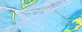 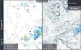 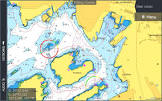 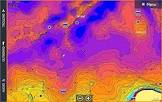 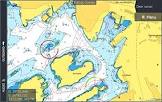 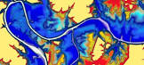 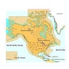 |
More Products


1Offer at $128.82
09/28/2022 -
Sears on Sears
$128.82
- Illinois
offer flagged
flag
+1
vote up
04/19/2024 12:50:55 [WSPG6F5AF0D30180058C0E48]
[DM-N]
Post your offer
More Products
ULTRA-WIDE COVERAGE: Our largest geographical coverage, without compromising on chart quality | HIGH-RES BATHY: Helps you identify shallow areas, drop-offs, ledges, holes or humps. Now includes compiled and quality-controlled Genesis detail as part of singular HRB layer | FULL FEATURED VECTOR CHARTS: Making navigation easy by giving you accurate, up-to-date vector chart detail derive from official Hydrographic Office information | CUSTOM DEPTH SHADING: Set a clear safety depth, maintain a paper-like view or create your own custom shading | EASY ROUTING: Helps you automatically plot the shortest, safest route based on detailed chart data and your personalized vessel information. No subscription required. | COMPATIBILITY: Lowrance, Simrad, and B&G touchscreen fish finders and chartplotters
Cruising, fishing or sailing, C-MAP DISCOVER charts offer ultra-wide coverage and include all of the core features you need to make the most of your time on the water. DISCOVER includes the very best of C-MAP High-Res Bathy, including integrated Genesis data, full-featured Vector Charts with Custom Depth Shading, Tides & Currents and subscription-free Easy Routing. Purchase includes 12 months of free online updates. Compatible with Lowrance, Simrad & B&G chartplotters. Key FeaturesUltra-Wide Coverage the largest geographical coverage, without compromising on chart quality.High-Res Bathy helps you identify shallow areas, drop-offs, ledges, holes or humps. Now includes compiled and quality-controlled Genesis detail as part of singular HRB layer.Full Featured Vector Charts making navigation easy by giving you accurate, up-to-date vector chart detail derive from official Hydrographic Office information.Custom Depth Shading set a clear safety depth, maintain a paper-like view or create your own custom shading.Easy Routing helps you automatically plot the shortest, safest route based on detailed chart data and your personalized vessel...
Recent Activity not available
C-MAP Entdecken Sie die Kartenkarte North America Lakes USA/Kanada für die Marine-GPS-Navigation
C-MAP 探索北美湖泊美国/加拿大地图卡用于海洋 GPS 导航
C-MAP 北米の湖を発見する米国/カナダの地図カード (海洋 GPS ナビゲーション用)
C-MAP Discover North America Lakes Tarjeta de mapa de EE. UU./Canadá para navegación GPS marina
C-MAP Откройте для себя озера Северной Америки Карта США/Канады для морской GPS-навигации
C-MAP Odkryj kartę mapy jezior Ameryki Północnej w USA/Kanadzie do morskiej nawigacji GPS
C-MAP समुद्री जीपीएस नेविगेशन के लिए उत्तरी अमेरिका झीलों यूएस/कनाडा मानचित्र...
C-MAP Descubra o cartão de mapa dos lagos da América do Norte EUA/Canadá para navegação GPS marítima
...